
I thought I would have the time to keep updating this site while in graduate school, but I don't, so I'm done here. It was fun.
- Mark Ellinwood
Sunday, October 4, 2009
Wednesday, August 5, 2009
Lack Of Updates... For Good Reason
Between work and my personal life, I have often been too tired to do things. Unfortunately, that means this site has gone onto the back burner for awhile. I am in day 3 of 7 of 8- or 9-hour work days, and then I have to pack for my move to Raleigh, NC, get accustomed to the school, and find a job and a roommate. Needless to say, all of these things cause get stress and other fun emotions and feelings that make it difficult for me to get the motivation to update the site.
- The Management
- The Management
Friday, July 10, 2009
June Was A Snoozefest... Will It Get Better?
It has been awhile since I posted... mainly due to working two jobs and figuring out the next step in my life... but who cares, time for some weather!
It certainly took awhile for June to get crankin' with the severe weather in NY. The first day was a clustered hail event from June 9th:
06/09/09:
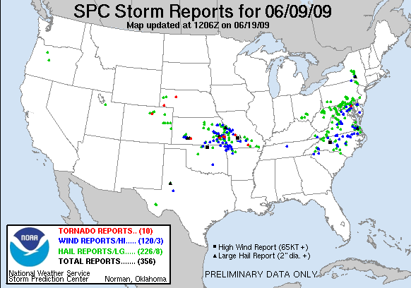
It took another week to get severe weather to strike NY. Once again, it was a hailer, and it struck a good portion of the eastern half of the state. The lack of wind reports in June was mostly caused by having weak shear, which couldn't organize severe storms into a line. Albany got some nice hail this day, but of course I was out of town:
06/15/09:

And that's all we saw for the first 24 days of June.
Severe weather started to return to a regular summer schedule once the last week of June hit. A low pressure system came through with some decent forcing to go along with daytime heating, giving us two exciting days of severe weather:
06/25/09:
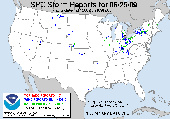
06/26/09:

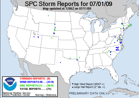
Daytime heating and a weak cut-off gave us a couple of bouts of severe weather a week later, with reports coming in from eastern NY on June 30th and July 1st:
06/30/09:

07/01/09:
Up to this point, all of the storms in June that gave us severe weather were either cut-offs, or become cut-offs. A similar situation came up on July 7th, but moved out of the northeast a bit quicker than the previous storms:
07/07/09:

It looks like this trough which has been keeping us cool this summer will stick around for a bit longer. I'm hoping that it moves out before I move to NC in a month, but it does not look promising at this time.
Tomorrow is looking really good for severe weather for NY, especially western and central portions of the state. I believe the SPC has underestimated the eastward extent of the severe weather (which I have been saying for a couple of days now), and that eastern NY will get a good showing from this low pressure system as it slides into the region in the late afternoon and evening hours.
It certainly took awhile for June to get crankin' with the severe weather in NY. The first day was a clustered hail event from June 9th:
06/09/09:
It took another week to get severe weather to strike NY. Once again, it was a hailer, and it struck a good portion of the eastern half of the state. The lack of wind reports in June was mostly caused by having weak shear, which couldn't organize severe storms into a line. Albany got some nice hail this day, but of course I was out of town:
06/15/09:
And that's all we saw for the first 24 days of June.
Severe weather started to return to a regular summer schedule once the last week of June hit. A low pressure system came through with some decent forcing to go along with daytime heating, giving us two exciting days of severe weather:
06/25/09:
06/26/09:
Daytime heating and a weak cut-off gave us a couple of bouts of severe weather a week later, with reports coming in from eastern NY on June 30th and July 1st:
06/30/09:
07/01/09:
Up to this point, all of the storms in June that gave us severe weather were either cut-offs, or become cut-offs. A similar situation came up on July 7th, but moved out of the northeast a bit quicker than the previous storms:
07/07/09:
It looks like this trough which has been keeping us cool this summer will stick around for a bit longer. I'm hoping that it moves out before I move to NC in a month, but it does not look promising at this time.
Tomorrow is looking really good for severe weather for NY, especially western and central portions of the state. I believe the SPC has underestimated the eastward extent of the severe weather (which I have been saying for a couple of days now), and that eastern NY will get a good showing from this low pressure system as it slides into the region in the late afternoon and evening hours.
Thursday, July 9, 2009
New York State Goes Green on 7 July 2009
Tuesday afternoon/night was an active one meteorologically speaking. Around 2:30PM (when I was getting ready to end my shift at work) intense rain came through the area. Flash Flood Warnings and Severe Thunderstorm Watches covered my area. I even saw very small hail (not large enough though to warrant snapping a cell phone picture). Lightning and thunder also made a very welcome visit to the area.
The appended images show the Storm Prediction Center's forecast and verification (storm reports) for the period around 7 July 2009.


Verification:
The attached base reflectivity images for 0300 - O500 UTC 8 July 2009 show very nice severe cells moving southeastward from New Jersey into New York Metro area.


When I came to work at KTEB yesterday morning, Chris and I immediately began discussing the situation to see if the damage reported was tornadic or straight-line wind related. Speaking with Dan (who was at the other office) we were discussing how it must have been straight-line wind, because the SRM and model soundings were crap.
Here is the Public Information Statement from NOAA NWS OKX:
http://forecast.weather.gov/product.php?site=NWS&product=PNS&issuedby=OKX
Well I should get back to work...and by that I mean looking at METARs and GFS loops until we get a phone call or have to record a radio forecast.
The appended images show the Storm Prediction Center's forecast and verification (storm reports) for the period around 7 July 2009.
Verification:
The attached base reflectivity images for 0300 - O500 UTC 8 July 2009 show very nice severe cells moving southeastward from New Jersey into New York Metro area.
When I came to work at KTEB yesterday morning, Chris and I immediately began discussing the situation to see if the damage reported was tornadic or straight-line wind related. Speaking with Dan (who was at the other office) we were discussing how it must have been straight-line wind, because the SRM and model soundings were crap.
Here is the Public Information Statement from NOAA NWS OKX:
http://forecast.weather.gov/product.php?site=NWS&product=PNS&issuedby=OKX
Well I should get back to work...and by that I mean looking at METARs and GFS loops until we get a phone call or have to record a radio forecast.
Thursday, June 25, 2009
NYC Severe Weather Threat for 26 June 2009
Well after what seems like an eternal wait, New York City is in the middle of a nice big SLGT by the SPC. The beginning of this week was plagued by a pesky upper-level cut-off low parked near Cape Cod, bringing rain showers and below-climo temps to our region. Finally, we have a nice set up for hot summer days and good convection.
The SPC Day 2 outlook right now has NYC under a SLGT, with a 15% categorical outlook. A series of shortwave troughs are expected to help amplify the weak zonal pattern we've had for weeks. SBCAPE should build throughout the day to over 3000 J/kg after 1800 UTC.

This is the NAM's forecast precipitation/pressure/isotherms for 00UTC 27 June 2009. Other more high-resolution models show much more precip, and PWATs are progged to be at least 1.5 inches. Here is the SPC forecast:


Upper level jet dynamics are decent, with a 60-kt jet streak at 250-hPa with NYC being placed in the right entrance region. Strong cyclonic vorticity advection at 500-hPa is present and the GFS is most aggressive with the negative tilting of the trough. Mixing rations of 12+ g/kg are present, so our atmosphere will be nice and moist.
More updates will follow as I try to stay awake.
The SPC Day 2 outlook right now has NYC under a SLGT, with a 15% categorical outlook. A series of shortwave troughs are expected to help amplify the weak zonal pattern we've had for weeks. SBCAPE should build throughout the day to over 3000 J/kg after 1800 UTC.
This is the NAM's forecast precipitation/pressure/isotherms for 00UTC 27 June 2009. Other more high-resolution models show much more precip, and PWATs are progged to be at least 1.5 inches. Here is the SPC forecast:
Upper level jet dynamics are decent, with a 60-kt jet streak at 250-hPa with NYC being placed in the right entrance region. Strong cyclonic vorticity advection at 500-hPa is present and the GFS is most aggressive with the negative tilting of the trough. Mixing rations of 12+ g/kg are present, so our atmosphere will be nice and moist.
More updates will follow as I try to stay awake.
Sunday, June 7, 2009
Severe Weather Just Around The Corner
The next couple of days are looking somewhat favorable for severe weather in NY. At the moment, it does not look like there will be much. Most of the action will depend on the placement of the fronts, which favors western and southern portions of NY at this time. Further north, expect showers and thunderstorms as well, but these storms will be elevated. Strong winds and small hail will be possible with these storms. The GFS has more favorable severe weather conditions further north than the NAM does, but the GFS is bringing the line further and further south as we approach game time.
At any rate, some of NY could get a nice light show from these storms. My camera will be ready.
Also, sorry for only 1 update again this week... been having problems with my computer (I have completely reformatted and reinstalled stuff over the weekend).
At any rate, some of NY could get a nice light show from these storms. My camera will be ready.
Also, sorry for only 1 update again this week... been having problems with my computer (I have completely reformatted and reinstalled stuff over the weekend).
Sunday, May 31, 2009
Cold... Then Seasonal... Boomers Are But A Distant Memory
This was probably one of the worst Mays (with the lack of severe weather) that NY has seen in a long time. The only shot I've gotten is a part of a double rainbow (which I may post later). This next week isn't looking that good for storms, except for a slight chance in western NY (where all of the storms seem to be happening this year).
There is a chance for thunderstorms across NY this Wednesday, but that's being highly optimistic at this point and time. The models have the cold front of the system coming through NY in the overnight through early afternoon hours. If that frontal passage comes through just a few hours later than what is currently anticipated, we might have a chance at some severe weather.
At least we're not the only ones without severe weather. The poor people with Vortex2 are missing out big time because of this unfavorable weather pattern. There hasn't even been a moderate risk area anywhere in the U.S. since the 15th.
In the meantime, I'll be catching up on my sleep.
Wednesday, May 27, 2009
Boomers On The Way... Past Reports For Now
As NY prepares for another round of thunderstorms for the second half of the week, we need to take a look back at last weekend's severe weather reports...
The 23rd provided NY with a few severe reports from a cluster of cells in southern NY. General thunderstorms impacted a good portion of NY that day:
05/23/09:

The next day was a bit more active, with a cluster of reports in southern NY and southern New England. What was interesting was the SPC never issued a watch for southern New England, which surprised me and many others:
05/24/09:

The 23rd provided NY with a few severe reports from a cluster of cells in southern NY. General thunderstorms impacted a good portion of NY that day:
05/23/09:
The next day was a bit more active, with a cluster of reports in southern NY and southern New England. What was interesting was the SPC never issued a watch for southern New England, which surprised me and many others:
05/24/09:
Friday, May 22, 2009
Possible End To Snoozefest 2009
After almost a full week of catching up on its sleep, severe weather may be back in NY tomorrow.
It has definitely been a unique Spring week...Nothing happening across most of the country, except in the Southeast, where parts of Florida have received over two FEET of rain over the past several days, due to the on-again off-again 90L, which is trying to reorganize itself before it pushes up through the middle of the country.
Here's the link to some extraordinary pictures taken at the Daytona International Speedway: Daytona flood pictures
Cloudcover will be an issue in NY again tomorrow as far as severe weather is concerned. With sufficient daytime heating, the atmosphere could destabilize enough for some hail and strong (but not severe) winds. These storms will likely be concentrated to central and southern NY, with some lingering cells edging their way into eastern NY late in the day.
Sunday, May 17, 2009
Two Tornadoes Now Confirmed From Yesterday's Storms
A Public Information Statement from the NWS:
... Tornadoes confirmed in Cortland and Madison counties...
Location... Georgetown... Madison County NY
date... may 16th 2009
estimated time... 434 to 447 PM
maximum ef-scale rating... EF2
estimated maximum wind speed... 100 to 120 mph
maximum path width... 150 yards
path length... 6.5 miles
beginning lat/Lon... 42.75n / 75.77w
ending lat/Lon... 42.77n / 75.67w
*injuries... 1
*note these numbers could change after issuance of this product.
... Summary...
most of the damage along the path was to trees. Significant damage
occurred approximately 1 mile south of the Village of Georgetown. A
large barn was destroyed... a roof was torn off a house and several
outbuildings and sheds were destroyed. Electrical poles were
snapped. This location is where the injury occurred. A second farm
on Upham Road was hit... destroying a large barn... silo and a couple
sheds. Some livestock was lost at this location. A Farmstead near
Niles Road also received damage to a silo... and damage to the home
roof and siding.
... Tornado confirmed in Cuyler New York...
Location... Cuyler... Cortland County NY
date... may 16th 2009
estimated time... 424 PM
maximum ef-scale rating... EF0
estimated maximum wind speed... 70 to 80 mph
maximum path width... 75 yards
path length... 0.4 miles
beginning/ending lat/Lon... 42.72n / 75.90w
*note these numbers could change after issuance of this product.
... Summary...
some trees uprooted and two small sheds destroyed. Greater damage
occurred to the west at a couple of farms and several residences
between Truxton and Cuyler which was determined to be caused
by straight line winds.
----------
UPDATE
Some articles:
wsyr9.com ABC Central NY
wktv.com News Channel 2 Utica
Tornado In Tioga County During Yesterday's Severe Weather
Wind, hail, and a tornado report can be seen cluttering the SPC Storm Report map over NY. Yesterday, an advancing frontal system pushed through NY. The warm sector was conducive to single-cell severe storms, which meandered across portions of central and southern NY during the afternoon hours:
05/16/09:

Once again, the timing of the system gave the western 2/3 of NY the upper-hand in instability, compared to the eastern 1/3 of NY. I heard a rumble of thunder from IC lightning every now and then as the main line pushed through Albany, but was otherwise uneventful.
05/16/09:
Once again, the timing of the system gave the western 2/3 of NY the upper-hand in instability, compared to the eastern 1/3 of NY. I heard a rumble of thunder from IC lightning every now and then as the main line pushed through Albany, but was otherwise uneventful.
Tuesday, May 12, 2009
Storm Reports From This Weekend
A hail report squeaked its way into NY Friday ahead of the main day of storms, as a couple of isolated cells that night showed severe potential, with the one producing:
05/08/09:

Saturday was the big day across NY and the Northeast. The Capital District saw some thunderstorms, but I wasn't able to get any good pictures, save a video or two of some interesting cloud structures. MA and NH each saw weak tornadoes as the storm pushed east, which makes me extremely jealous:
05/09/09:

There is a new threat lining up for NY and the Northeast this upcoming Saturday. Unfortunately, this is my graduation weekend, and I will be occupied with other things for most of the day Saturday. Hopefully I get to see something interesting.
05/08/09:
Saturday was the big day across NY and the Northeast. The Capital District saw some thunderstorms, but I wasn't able to get any good pictures, save a video or two of some interesting cloud structures. MA and NH each saw weak tornadoes as the storm pushed east, which makes me extremely jealous:
05/09/09:
There is a new threat lining up for NY and the Northeast this upcoming Saturday. Unfortunately, this is my graduation weekend, and I will be occupied with other things for most of the day Saturday. Hopefully I get to see something interesting.
Saturday, May 9, 2009
Severe Weather in New York State Nearing Imminence


Greetings all...It is currently 1609 UTC, and much of New York State is under a "Slight" risk for severe thunderstorms by the SPC. Albany is literally smack in the middle of this threat zone, with 5% chance for damaging tornadoes and 15% chance for damaging wind/large hail. Several of us Metards will be attempting to "chase" later on assuming things heat up nicely. As detailed by Mark Ellinwood in yesterday's post, L-I-F-T is present and is increasing as we get insolation. Some nice graphics are appended, and more updates (possibly from the road) will follow.....
...cue Van Halen's "Humans Being", maestro!
1630 UTC UPDATE (from Ellinwood):
SPC has updated the wind threat to a 30% chance over NY:

A severe thunderstorm watch has also been issued for most of NY:
Friday, May 8, 2009
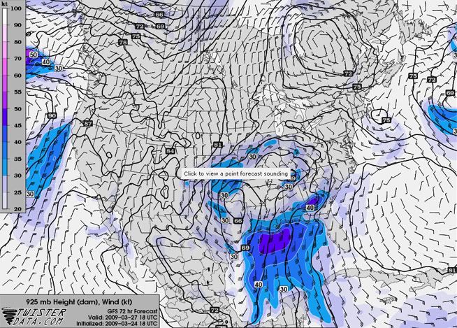
Severe Weather Possible Tomorrow
NY is primed for thunderstorms tomorrow afternoon and evening. A shortwave trough will speed through the region, bringing strong upper-level dynamics into a somewhat-unstable atmosphere. All of this spells "L-I-F-T," which could lead to some severe weather.
SPC still seems to be underplaying the probability for severe weather, keeping most of NY in the 5% region. However, the 15% bubble has been slowly creeping north over the last few days, which may mean good things for further upstate.
The main concern is that wonderful stuff we like to call "clouds." If the Sun can break them up sufficiently tomorrow, we can see the chance for severe weather rise pretty quickly.
Great wind profile, SFC CAPE progged by NAM and GFS to be around 1000 J/kg... gonna be a good day!
Also expect strong winds following the frontal passage as the powerful shortwave pushes east Saturday night into Sunday.
(click sounding to enlarge)
Sunday, May 3, 2009
Another Week Of No Boomers Ahead For NY
The models are not supporting any type of severe weather, or even general thunderstorms, for most of NY for the upcoming week. I'm starting to lose my patience, as the last few attempts of a thunderstorm in Albany either never happened, or died out before reaching us.
Perhaps a shower or two will be around in the upcoming week, with some areas of heavier rain. NYC and Long Island could see some good amounts of precip by the end of the week. Other than that, temps will be near average for this time of the year. We may see a slight warm-up towards the second half of the week, but it will also be accompanied by cloudy skies and occasional precip.
Sorry I waited until the last day to make the minimum of two updates. It's been a very busy week.
Research On Marcellus And Utica Tornadoes Complete
I've finished my research for the 29 July 2006 tornadoes of Marcellus and Utica, NY. I will not post my results quite yet, as I will probably need to clean it up a bit and maybe try to get it published.
At any rate, here's the original abstract:
On 29 July 2006, a line of storms produced two F0 tornadoes in Marcellus and Utica, NY at approximately 2000Z and 1930Z, respectively. To investigate the cause of these tornadoes, an analysis of the synoptic, mesoscale and air column data was performed. The synoptic analysis of the surface and upper-levels indicates forcing for ascent along a surface cold front, which was enhanced by a weak 300 hPa jet streak aloft. Air column data suggests thermodynamic forcing for ascent in the mid- and upper-levels from Convective Available Potential Energy (CAPE). Forcing for ascent is also indicated by the veering wind profile and wind speeds increasing with height throughout most of the troposphere. The analysis of the mesoscale data reveals the true culprit behind the tornadogenesis that occurred over Marcellus and Utica.
Saturday, April 25, 2009
Oswego County Hit By Hail
An unexpected hail report came in from the north country as scattered showers and thunderstorms moved through the region on the 21st:
4/21/09:

More severe weather is expected throughout the next few days as a couple of fronts make their way through NY. Parts of NY saw thunderstorms overnight last night, and more are entering western NY and pushing east tonight.
I will be waiting patiently, camera at the ready.
4/21/09:
More severe weather is expected throughout the next few days as a couple of fronts make their way through NY. Parts of NY saw thunderstorms overnight last night, and more are entering western NY and pushing east tonight.
I will be waiting patiently, camera at the ready.
Tuesday, April 21, 2009
My Research From the 2009 NESC
I've finally gotten around to uploading a .pdf of my 2009 NESC presentation. The link will likely change after my web space from SUNY Albany is taken away, but I will put it up on there for now. I should really find a more permanent place to put that stuff...
The research has a synoptic scale analysis, as well as a closer look into the mesoscale features of the case studies. This is mostly preliminary research, and more cases could be added in the future. I will probably not continue this research, as I have seen others working on similar situations involving elevated convection, such as Nolan Atkins and Todd Lanouette, who, are working on bow echo storms. They've already come up with some great conclusions about elevated convection that further research on my part would only back up their findings, and not provide a significant contribution to the scientific community.
A Comparison of Cold Season Non-severe Wind Storms and Severe Wind Outbreaks in New York State
NOTE: The "which is which?" slides are animations that do not work on the PDF, so you may disregard those two slides. They merely show the similarity between the radar signatures of surface and elevated convection.
Sunday, April 19, 2009
Thunderstorms And Severe Weather May Push Into The Northeast
Over the next few days, an upper-level trough will work its way out of the southern Great plains and push northeast through the Midwest. It's looking like NY will see two bursts of precipitation associated with this trough tomorrow and Tuesday. The first one will be along an occluded front of a weakening system that is currently centered over the southern Great Plains. The most southern parts of NY could hear some rumbles of thunder from elevated convection with this first line of storms as it pushes through tomorrow evening. Both the GFS and NAM are in excellent agreement as to the timing and amount of precipitation associated with this line of storms.
As this storm lifts out of the upper-level trough, another system will dig into the trough, briefly intensifying it Tuesday before the trough lifts off to the northeast. This could provide southern and eastern NY with a brief period in the warm sector of the low pressure system, which could fuel some decent thunderstorms. A few of these storms may produce small hail and gusty (but non-severe) winds.
Tomorrow:

Tuesday:

But all of this is nothing compared to what we have coming up.
Over the weekend, we're looking at the first real chance for good severe weather in NY. A strong ridge will be in place over the eastern US during the week, and will provide a nice southerly flow in the latter part of the week. This will help draw Gulf moisture and warm temperatures into NY ahead of an upper-level trough, which will be digging down from central Canada. This trough is progged by the GFS to bottom-out just to the west of NY. The GFS may be a little bold with the strength of the instability at this point and time, but high temperatures this weekend are forecast to be a bit warmer than the GFS indicates (as the GFS trends towards climo this far out), so it could also be underplaying some aspects of the instability as well.
Based on the GFS forecast, it looks like a line of storms oriented SW-NE will push east along a cold front through NY Sunday afternoon, providing strong winds and some hail. This is definitely THE storm to track through the upcoming week. Hopefully it will pan out!
Sunday afternoon:
As this storm lifts out of the upper-level trough, another system will dig into the trough, briefly intensifying it Tuesday before the trough lifts off to the northeast. This could provide southern and eastern NY with a brief period in the warm sector of the low pressure system, which could fuel some decent thunderstorms. A few of these storms may produce small hail and gusty (but non-severe) winds.
Tomorrow:
Tuesday:
But all of this is nothing compared to what we have coming up.
Over the weekend, we're looking at the first real chance for good severe weather in NY. A strong ridge will be in place over the eastern US during the week, and will provide a nice southerly flow in the latter part of the week. This will help draw Gulf moisture and warm temperatures into NY ahead of an upper-level trough, which will be digging down from central Canada. This trough is progged by the GFS to bottom-out just to the west of NY. The GFS may be a little bold with the strength of the instability at this point and time, but high temperatures this weekend are forecast to be a bit warmer than the GFS indicates (as the GFS trends towards climo this far out), so it could also be underplaying some aspects of the instability as well.
Based on the GFS forecast, it looks like a line of storms oriented SW-NE will push east along a cold front through NY Sunday afternoon, providing strong winds and some hail. This is definitely THE storm to track through the upcoming week. Hopefully it will pan out!
Sunday afternoon:
Friday, April 17, 2009
Amazing Sounding: Corpus Christi
Get a napkin ready to wipe the drool off of your face after you see these soundings:
You don't see stuff like this very often!
You don't see stuff like this very often!
Wednesday, April 15, 2009
Researching The 2006 Marcellus, NY Tornado
Not much in the way of exciting weather is going on this week. Hopefully we'll see a more favorable environment for storms in the Northeast somewhere around the end of April.
For one of my classes, I have decided to do a case study of the F0 tornado that struck my hometown of Marcellus, NY back in 2006. I will post the paper here when it is done.
For those of you wondering why I haven't put up my research from earlier this year up, it is because I forgot to. I'll put a research tab on the left-hand link area and throw the powerpoint and other stuff in there.
It looks like I may be going to NCSU in the fall, so I will probably not have any more NY pictures to post after the move. However, I will keep updating this site and adding on to it, and I will probably also start another blog that is more general and caters to me having to move around a bit over the next several years. This blog has been going for about a year now (1 year anniversary is April 19th, yay us!), and I have learned a lot from doing it. I hope that people other than myself have found this site to be useful in one way or another.
Sunday, April 12, 2009
Brushfire Leads To 6-Alarm Blaze On Staten Island
Around 1:00pm local time, a brush fire broke out on Staten Island. It has quickly grown into a 6-Alarm fire, and is threatening homes and infrastructure. One home is completely engulfed in fire, and other houses are at risk of becoming ablaze as strong winds push the smoke and ash southeastward.
Here is a radar from earlier today, with the smoke plume clearly visible to the southeast of Staten Island:
Links with early reports on the fire:
http://www.silive.com/news/index.ssf/2009/04/brush_fire_on_staten_island_ca.html
http://www.ny1.com/content/top_stories/97273/crews-battle-massive-brush-fire-on-staten-island/Default.aspx
More news on the brush fire as it develops. Fellow blogger Mark McIntyre is within three-minute walking distance from his house to the intense fires, and he will have some eyewitness information for us soon.
Saturday, April 11, 2009
Dry Northeast Starting To See Drought Conditions Arise
Since the start of the year, NY and the Northeast has seen below-average precipitation amounts, and it's starting to show. Below average monthly precipitation totals have been recorded throughout most of NY since January, and the next week looks like it will only add to the deficit, as a series of high pressure systems keep rain out of the Northeast.
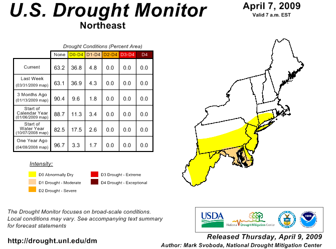
While drought conditions are still relatively minor, a couple more months of prolonged dry weather could see these conditions rapidly deteriorate, which does not bode well for farmers as planting season for many crops is just around the corner.
To keep up with the drought conditions in the Northeast, you can visit the following link:
http://www.drought.unl.edu/dm/DM_northeast.htm
Thursday, April 9, 2009
Lull In NY Weather, So Here's A Couple Weather Links!
Since it looks like the weather in NY will be pretty boring for awhile, here's a couple of weather links to keep you on the up-and-up on forecasting!
1. METAR data (defaulted to KALB for 60 hours) - Courtesy of UCAR
What it is: This site shows us the METAR weather code for virtually any station. This link is so special because it was really hard for me to find.
Why it's awesome: Take a good look at the URL. This link is for KALB, but you can enter any four-letter station ID you wish. Also note the "hoursStr=past+60+hours" section. The 60 can be made to any 12-hour interval you desire, for up to a month out into the past (~756 hours max)! This is a very nice feature, as you can look up what kind of weather a station has been having for the last month, which is useful to those who participate in forecasting contests like myself.
2. TwisterData.com - Courtesy of TornadoVideos.net
What it is: A high-res look at the nation from the GFS and NAM forecast models. This site is pretty expansive in its features, allowing you to look at dozens of different model outputs in an easy-to-navigate manner.
Why it's awesome: Easy to use, awesome features, and it's still in its infancy! Expect to see new features added to this site to make it even more user friendly in the near future, along with more model data (see the site for specific details). It also has a four-day archive of model outputs, so you can compare 16 different NAM/GFS runs if you want to! This site makes it really easy to look at severe weather components, which saves me a bunch of time since I don't have to look at several different sites to get my wind, moisture, and sounding data anymore.
Take them, cherish them, and get to know them! These two links provide me with a lot of information that I use on a regular basis, and I hope you will find them as useful as I do!
Sunday, April 5, 2009
Another Chance For Elevated Convection For Monday. Also, Snow...
As yet another low pressure system pushes into the Northeast, NY is faced with the possibility of thunderstorms associated with elevated convection. The thunderstorms are expected to pop up along an occluded front Monday morning, and push northeast from western NY to eastern NY throughout the mid-morning and afternoon hours.
The GFS is being a lot more generous than the NAM with elevated CAPE in NY, with values of over 800 J/kg over Albany at around 2pm EDT. NAM is suggesting more moist mid- and upper-levels, with elevated CAPE values of less than 100 J/kg. P-Wat values of about one inch will help fuel the storms as they push through NY.
The main discrepancy between the models is the overall strength of the mid- and upper-level jets over NY. The GFS is forecasting stronger mid- and upper-level winds, which would advect steeper lapse rates into these levels and provide the larger elevated CAPE values. I tend to go with a mean value over Albany, since the GFS tends to overestimate CAPE values, and the NAM slightly underestimates it. Realistically, I would expect Albany to hit elevated CAPE values of 200-300 J/kg...enough to trigger some boomers!
This line of possible thunderstorms will also bring heavy rain, with a large portion of NY progged to receive over half an inch of precipitation. Lesser values are forecasted for areas not fully affected by this line of storms.
Following the passage of the occluded front, snow is expected throughout most of NY. Temps will reach below freezing at times in much of the western half of NY, which could see some snow accumulations. Areas affected by lake effect could see very generous snowfall totals for this time of the year, with 3-6"+ expected in the stronger lake-effect bands. In the eastern half of NY, temps will be a bit warmer, so valley areas could see some snow showers mixed with rain, but little to no accumulation. Elevations above 1200' in eastern NY can expect to see some snow accumulation from the trailing end of this storm.
Thursday, April 2, 2009
Thunderstorms in ALB tomorrow?
So after the nice complex of storms that affected the Southeast and Gulf Coast states today, us weather nerds up here at UAlbany are looking forward to the possibility of more thunderstorms tomorrow. The 990-hPa low that is currently over AR/TN will make its way northeastward towards us, eventually taking a track west of the Capital Region. Appended is the SPC's current Day 2 outlook, followed by total precipitation forecast ending 0000Z 4 April 2009.


Monday, March 30, 2009
Storm Creates One Last Day Of Havoc As It Moves Off The Coast
The most recent storm, which brought plenty of severe weather across the Southeast and Mid-Atlantic, still had a trick up its sleeve before moving off the coast yesterday. A very stacked and very strong low pressure center worked its way over PA and NY, which brought a great amount of energy into the region. This energy took the form of severe thunderstorms, which worked their way over the eastern half of PA, eventually coming into contact with NJ, southern NY and NYC/LI.
3/29/09:

Albany saw its first round of thunderstorm activity last night. Unfortunately, I was at work, and could not really watch it or take any video.
Welcome to Spring!
3/29/09:
Albany saw its first round of thunderstorm activity last night. Unfortunately, I was at work, and could not really watch it or take any video.
Welcome to Spring!
Sunday, March 29, 2009
Staten Island Got Hail!
Yes, Staten Island managed to get hail with the line of storms that passed through tonight. The size was 0.88", or nickel-sized, which qualifies the thunderstorms as severe! Here is the verification from the SPC:
0015 88 8 SW TOMPKINSVILLE RICHMOND (STATEN NY 4055 7418 NICKEL SIZED HAIL (OKX)
And here is the image of all of the storm reports from the SPC:

Here is an image of the hailstones that my little brother took during the storm:

0015 88 8 SW TOMPKINSVILLE RICHMOND (STATEN NY 4055 7418 NICKEL SIZED HAIL (OKX)
And here is the image of all of the storm reports from the SPC:
Here is an image of the hailstones that my little brother took during the storm:

Severe Weather Hits NYC and I'm NOT THERE!
Well, NYC is about to get its nice first batch of severe weather of the season, and I'm not at home. I'm working on my Synoptic II paper, but still monitoring the radar, and I must say, it looks nice. A very well-defined hook echo was visible tracking northeastward from Bergen County (NJ) into Rockland County (NY). More posts will come later when it has passed.
Saturday, March 28, 2009
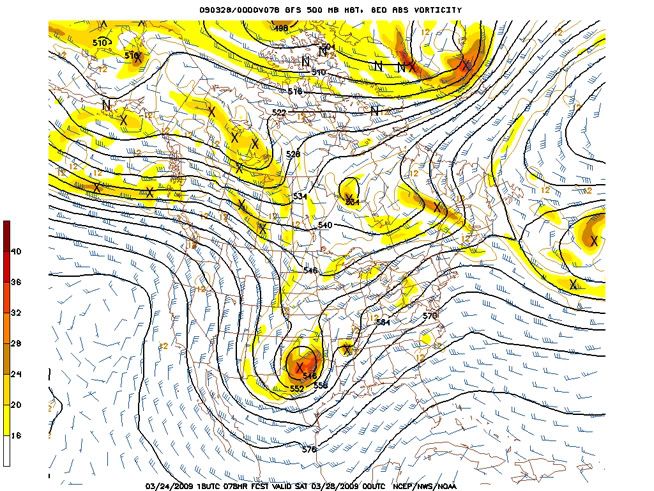
Elevated Convection Potential In NY Tomorrow
The storm that is currently wreaking havoc from the Great Plains eastward is going to push into the northeast over the next couple of days. Most of the upper-level forcing associated with this storm will be over western NY on Sunday, and will push eastward in the afternoon and overnight hours. Elevated CAPE values in the 500-800 J/kg range will also help lift air parcels and create some interesting weather over NY tomorrow.
There is a possibility of an elevated squall line development along the cold/occluded front tomorrow across NY and PA eastward. While NY may only get a taste of it, it just needs to get far enough north to let me snap some shots of it! The only downfall is that I work tomorrow evening, so the chance to watch it depends solely on when the front plans on passing through.
From the most recent AFD from the ALY NWS:
A SECONDARY CONCERN FOR SUNDAY...WHICH COULD HAVE A DIRECT IMPACT ON
QPF AMOUNTS...IS FOR ANY ELEVATED CONVECTION. THE LATEST 12 UTC
NAM12 SHOWS FORECASTED SHOWALTER VALUES LESS THAN ZERO ACROSS THE
ENTIRE CWA JUST BEFORE THE PASSAGE OF THE OCCLUDED BOUNDARY...WITH
VALUES AS LOW AS -3.5 MOVING FROM ACROSS THE SCHOHARIE VALLEY AND
CAPITAL DISTRICT. THE NAM12 IS ALSO VERY IMPRESSIVE WITH FORECASTED
850-500 HPA LAPSE RATES OF 6.5-6.9 DEGREES C/KM. ALONG WITH LOCALLY
HEAVIER RAINFALL AMOUNTS...LAPSE RATES OF THIS MAGNITUDE COULD ALLOW
FOR SOME SMALL SOFT HAIL /GRAUPEL/ AS WELL. THE THREAT FOR THUNDER
WOULD BE INCREASED AS WELL IF ANY BREAKS IN THE CLOUDS
OCCUR...ALTHOUGH BOTH THE NAM12/GFS IMPLY ACCORDING TO 850 HPA RH
THAT THIS WOULD REMAIN FURTHER SOUTH ACROSS CENTRAL PA. INCREASING
THE CONFIDENCE IN THIS IS THE LATEST 12 UTC LOCAL HIRESWRF...WHOSE
FORECASTED COMPOSITE REFLECTIVITY SHOWS A BKN CONVECTIVE LINE
DEVELOPING LATE SUN AFTN ACROSS NORTHEASTERN PA...AND ADVANCES IT
TOWARDS OUR CATSKILL/MID HUDSON VALLEY ZONES BY EVENING. SPC ALREADY
HAS OUR REGION OUTLINED IN GENERAL THUNDER...WITH A SLT RISK
REMAINING TO OUR SOUTH ACROSS SOUTH JERSEY AND THE DELMARVA.
Tuesday, March 24, 2009
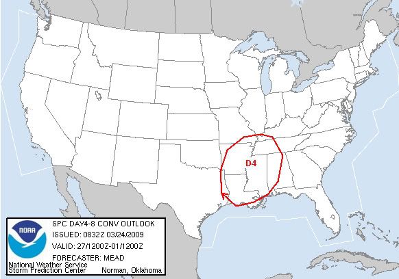
Strong Severe Outbreak Potential For The Southeast March 27-28
Though the exact timing and overall strength of the storm is still debatable, the models are agreeing that a significant storm will dig down from the Northwest into the large scale upper-level trough that is currently over the central U.S. during the second half of the work week. The main discrepancy in timing the storm lies as to whether or not the storm will cut-off, or remain in the main flow. This storm has the potential to wreak havoc from eastern Texas eastward across the Southeast. On the other side of the storm, widespread winter weather is possible for areas as far south as northern Texas, in a swath that extends north and east into the Great Lakes as time progresses.
The general consensus among the models shows an impressive upper-level vort max digging into the Texas region Friday as it bottoms out in the large-scale trough. An upper-level jet in the base of the trough will provide southwesterly winds, which will draw the dry upper-level air off of the Mexican Plateau into the South and Southeast. This will create good upper-level lapse rates and decrease the upper-level stability.
The cold front currently draped over the Midwest and Southeast will stall in the South and Southeast Wednesday, which will continually draw Gulf moisture into the Southeast over the next few days. A couple of weak systems are expected to form off of this boundary and move off to the northeast before the big storm makes its way in. There will be enough instability south of this boundary to initiate some severe weather Wednesday through Friday, but nothing significant is forecasted for this time period.
The low-level moisture that will be in place over the Southeast will provide a good source of instability for the main storm when it enters the region, with surface dewpoints forecasted to be in the lower 60s at the time of arrival of the storm. A Bermuda High will also be in place over the next few days, which will enhance the southerly flow off of the Gulf of Mexico.
Along with the impressive vort max in the 500mb level, The strength of the lower- and upper-level jets seem to be the major players for this storm. The main concern is with the forecasted strength of these jets. The GFS has the most robust forecast for this storm, with strong upper-level winds bringing in dry air aloft, and a strong southerly jet in the lower-levels, which will draw the moist Gulf air north and provide significant low-level wind speed shear. Weaker winds for either jet can quickly turn this disaster scenario into a more moderate event.
All that being said, I am going to side closely with the GFS, as it has done fairly well with forecasting the first few big troughs of the season, with surprisingly good accuracy in the 4-6 day range. Both the GFS and NAM are forecasting a generous area of 2000+ J/kg CAPE, with some areas possibly exceeding 3000 J/kg CAPE (with a bulls-eye over Louisiana). P-Wat values are forecasted to be in the 1.5"-1.75" range when the storm arrives in the Southeast. Impressive low-level speed and directional wind shear will lead to plenty hail and a good amount of severe wind and tornadic activity in the Southeast. A nice cap will also be present around the 850mb level, before getting eroded by diurnal heating and vertical motion, which rounds out the setup for a classic "loaded gun" environment.
Subscribe to:
Posts (Atom)
