
NYS could see some severe wind reports today, as a storm system makes its way across the state today. The front has already produced a line of storms, which formed over lake Erie and died out shortly after passing Rochester. A new line could form over lake Ontario, which would have the potential to produce severe winds.
The line that passed through western NYS early this morning has not produced any reports yet, but the winds were quite strong. The Buffalo airport recorded wind speeds of 41 knots, gusting to 65! Rochester airport, which caught the end of the line of storms, reported winds speeds of 40 knots, with gusts as high as 55 knots.
Even without severe storms, wind is still a concern, as the cold front passage will be accompanied by strong westerly winds.
Sunday, December 28, 2008
Tuesday, December 23, 2008
The Report That Sneaked By
A narrow line of storms brought in one wind damage report in western NY last week, which was a little surprising, but not necessarily unexpected.
12/15/08


(click for a radar loop in larger resolution)
The radar and sounding closely match my findings for what causes severe wind reports in NYS. I shall elaborate on this more when I have worked on my research a bit more.
Speaking of my research, I am going to refine my paper to just include winter cases, and submit it to the 34th Annual Northeastern Storm Conference. Hopefully, I'll get a spot to present my original research to the scientific community. Because of this, I won't put my findings up here until after that, should my paper get accepted.
12/15/08

(click for a radar loop in larger resolution)
The radar and sounding closely match my findings for what causes severe wind reports in NYS. I shall elaborate on this more when I have worked on my research a bit more.
Speaking of my research, I am going to refine my paper to just include winter cases, and submit it to the 34th Annual Northeastern Storm Conference. Hopefully, I'll get a spot to present my original research to the scientific community. Because of this, I won't put my findings up here until after that, should my paper get accepted.
Duo Snowstorms Pack A One-Two Punch
The last weekend of holiday shopping before Christmas was hindered in NYS by two snowstorms, which caused havoc on the roadways.
The first storm arrived on Friday, 12/19/08, around noontime at Albany. Conditions quickly worsened, as heavy snowfall limited visibility and made roads treacherous. The main part of the storm went on throughout the afternoon, and diminished in the evening hours. Flurries continued throughout the night, adding another inch or so to the storm total. Snowfall totals in the Albany area for this storm was between 8-10 inches.
Two days later, on Sunday, 12/21/08, a second storm rolled into the Capital Region in the late morning hours. Snowfall continued until the early evening, which provided the Albany area with another 6-8 inches of the white stuff.
My forecasts for both days for the Albany area was 7-9 inches for the Friday storm (which is what most people got), and 6-8 inches for the Sunday storm (nailed it!). Two for two so far... let's see how the rest of the season goes.
So here I sit, with 16 inches of snow at my front door. Add these storms to the ice storm from last week, and you've got one crazy start to the winter season!
Monday, December 15, 2008
Winter Storm Rocks NYS, New England
12/12/08:
A coastal storm ramped up and slammed into NYS and New England Thursday and Friday, leaving a massive streak of ice and flooding in its wake. Not even Albany was spared from the onslaught of ice, which accumulated up to an inch or more in areas. Due to the nature of the storm, with a warm layer aloft and northerly winds at the surface bringing in subfreezing temperatures to all local areas, despite the difference in elevation. This caused the entire region to get freezing rain, which was in abundance due to the high amount of moisture that was drawn northwards by the storm.
-----
While the city kept its power going throughout most of the storm, many others in the outlying neighborhoods spent the weekend without power, which may not return until later this week.
Many schools canceled afternoon activities on Thursday, as the winter storm crept its way into the region. The storm dumped heavy rain over the region Thursday evening into Friday morning, which turned to ice due to the below-freezing temperatures at the surface. Tens of thousands lost power overnight, as ice caused power lines and trees to fall. Many people spent their Fridays at home, stranded because of the ice storm.
Some of those without power also suffered from flooding, as sump pumps sat idle without a power source. A fortunate few without power were able to purchase a generator to keep their losses to a minimum. One person I spoke to visited as many as 15 stores looking for this weekend's number one most-sold product in the region before finally getting the last available generator at that store.
The University At Albany, one of the few schools to have power on (most) of the campus Friday, remained open for finals, despite the inability of some students and professors to commute to the school.
Cleanup will continue through the week, as energy companies rush to restore power throughout the region.
Sunday, November 30, 2008
So... What Happened?
Though we did not get the outbreak I was hoping for, a few reports did arise:
11/15/08

A strong line of storms moved through NY and PA into the New England states, but it just wasn't strong enough to be a severe wind monster. Details will come soon, as I am trying to incorporate it into my research project.
Speaking of my research, the rough draft is completed. A final draft will be posted next week, and I might put up my powerpoint when it's finished this week.
11/15/08
A strong line of storms moved through NY and PA into the New England states, but it just wasn't strong enough to be a severe wind monster. Details will come soon, as I am trying to incorporate it into my research project.
Speaking of my research, the rough draft is completed. A final draft will be posted next week, and I might put up my powerpoint when it's finished this week.
Saturday, November 15, 2008
The Tornado Watch for Albany NY and Surrounding Areas
Well well well, it seems as if Mother Nature felt like toying with us again. I was watching FOX23 when I saw that our friend and fellow ATM graduate Ryan Finn issued a Tornado Watch for our area. Sure enough, we had a good amount of shear, moisture, and instability (SWEAT at 12Z sounding was 232 with some good veering). Although we didn't get any twisters, Washington County to our north had a wind report. Hopefully we get something real before winter sets in for good.
Possible Severe Weather Lines Up For NYS
Although I have yet to post the findings of my research here, I would just like to note that I have completed the research.
Basically, today is lining up pretty well with my study of severe wind outbreaks that occurred during the late fall and early winter months, so the potential for a severe wind outbreak is definitely there.
As of now, portions of NYS, New England, and Mid Atlantic states are currently under a tornado watch... and for good reason!
So look out, eastern NYS and New England... it's gonna be a crazy day.
Saturday, November 8, 2008
Discovery Of New Sites Bring New Ideas
For a brief time, I was providing archived radar imagery and such for the severe weather events, only to find out that they stayed in the web site's database for a period of a week. While working on my research project, I was directed to several web sites, which have (among other things) archived radar and satellite (IR/Vis), and analyzed maps for upper-air stuff and what-not.
I will try to incorporate these things into my severe weather discussions and reports from now on.
*star swipe* The More You Know!
I will try to incorporate these things into my severe weather discussions and reports from now on.
*star swipe* The More You Know!
Wednesday, October 29, 2008
Strong Low Pressure System Brings Wind Damage
Rumbles of thunder could be heard over Western and Central NY on Sunday. A powerful cold front had plenty of lift, which helped trigger the storms. A couple storms became severe, and produced wind damage to Western NY:
10/26/08

This storm later produced small thunderstorms in Central NY, but nothing severe was reported. Here in Albany, we got nothing special from that front. However, that system set up a strong coastal storm, which had a huge impact on NYS. More on this later as I get more details.
10/26/08
This storm later produced small thunderstorms in Central NY, but nothing severe was reported. Here in Albany, we got nothing special from that front. However, that system set up a strong coastal storm, which had a huge impact on NYS. More on this later as I get more details.
Tuesday, October 14, 2008
Research Project On Severe Weather In NYS
I'm doing research for one of my classes, and I chose to look at severe weather outbreaks in NYS that involves numerous wind damage reports. I have found three "cold" and three "warm" cases to study and compare. Results, as well as the full article, will be posted here. The paper is due in early November, and the presentation will be done by early December.
I've revamped my old site to make it more suitable for my collegiate needs. The linked page contains my research stuff:
http://www.albany.edu/~me381243/atm400research.html
I've revamped my old site to make it more suitable for my collegiate needs. The linked page contains my research stuff:
http://www.albany.edu/~me381243/atm400research.html
Saturday, October 4, 2008
Cold Grips NYS ... Fall Is Here
As we make the transition from fun Summer days to miserable Autumn weather, one thing stands out the most: It gets really friggen cold at night! Albany got down to a chilly 36F last night, and I'm sure plenty of areas in NYS got some frost last night.
Now the leaves will start turning, making everything all nice and pretty...the one consolation for having to turn on the heat for the first time in four months.
I hope everyone has their warm clothes ready for this week!
Now the leaves will start turning, making everything all nice and pretty...the one consolation for having to turn on the heat for the first time in four months.
I hope everyone has their warm clothes ready for this week!
Saturday, September 20, 2008
Ike Remnants Impact NYS
The remnants of hurricane Ike moved through NYS, which helped induce a severe line of storms as it propagated north and east. This line had little lightning, and only produced wind damage reports.
09/14/08

It stayed too far north of Albany to make it a concern of mine (and it went by around 4am... wasn't gonna get up for it). Hopefully we'll see one more thunderstorm before fall hits and temps go down, down, down.
09/14/08
It stayed too far north of Albany to make it a concern of mine (and it went by around 4am... wasn't gonna get up for it). Hopefully we'll see one more thunderstorm before fall hits and temps go down, down, down.
Thursday, September 11, 2008
September Brings A Lull
With high pressure dominating the weather patterns over the northeast these last few weeks, little has been seen in the way of severe weather. In fact, NYS hasn't had any severe weather in a few weeks. In the meantime, Pennsylvania had a tornado when Gustav made its way up, and a strong cold front came through on the 9th and brought severe weather to our south and east. We got thunderstorms, but there were no severe reports.
It's been pretty quiet, and I'm still waiting for that one last hurrah before the thunderstorm season ends...so long as it's not at 8am like this last line of storms was.
It's been pretty quiet, and I'm still waiting for that one last hurrah before the thunderstorm season ends...so long as it's not at 8am like this last line of storms was.
Wednesday, August 27, 2008
Isolated Severe Cell Moves Over Long Island
Strong winds brought down some wires in Suffolk County, bringing in the one and only severe report for the last week or so:
08/25/08

It looks like we have a chance for thunderstorms sometime this weekend. It would be nice to see a little action after having absolutely nothing for so long.
08/25/08
It looks like we have a chance for thunderstorms sometime this weekend. It would be nice to see a little action after having absolutely nothing for so long.
Thursday, August 21, 2008
Severe Report Catch-Up Day... Last Time
It's been pretty hectic these last few weeks, and I had to neglect the site a bit. Now I'm back, and ready to keep this thing updated. Let's begin by throwing all the severe reports up:
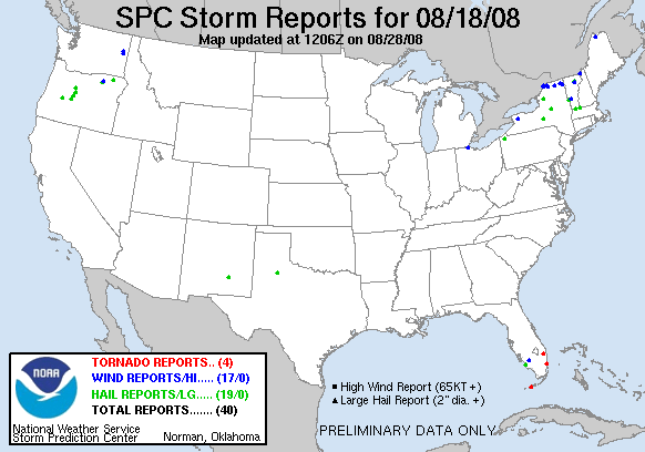
08/18/08
08/16/08

08/15/08

08/14/08

08/11/08

08/10/08

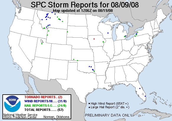
08/09/08
08/08/08

08/07/08

08/06/08

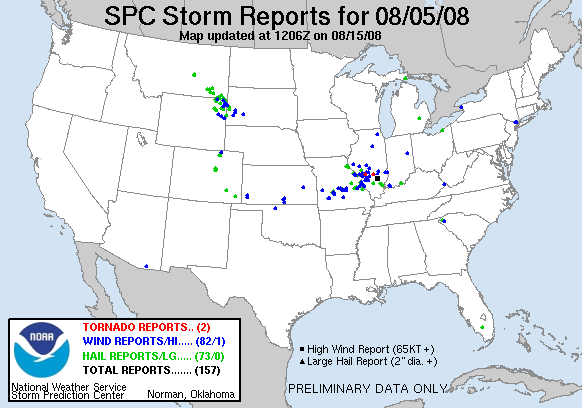
08/05/08
08/02/08

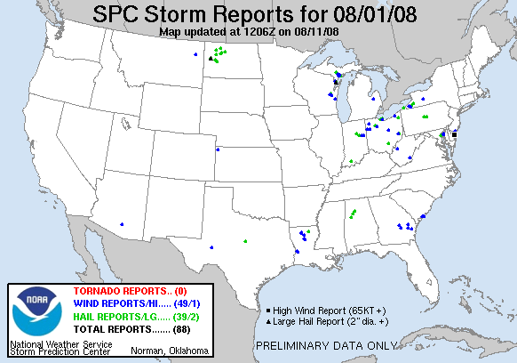
08/01/08
07/28/08

As you can see, it was quite an active period. Tornado warnings were issued on a few days, including for areas in the Bronx, but no tornado reports came in.
Now we're under a nice high pressure which will keep the severe weather away for awhile.
We'll continue to watch Tropical Storm Fay as it works its way through the southeast, providing some much-needed rain to that area. There's also Typhoon Nuri, which is threatening southeast China as its outer bands push onto the coast. Luckily, it should stay well south of Beijing, so it will have a minimal impact on the Olympics.
Getting pictures up has been a bit of a hassle with the new camcorder, but I'm working my way through what I've got. I have been putting pictures up here and there, but I still have footage to go through. I'll let you know when I've gone through everything.
08/18/08
08/16/08
08/15/08
08/14/08
08/11/08
08/10/08
08/09/08
08/08/08
08/07/08
08/06/08
08/05/08
08/02/08
08/01/08
07/28/08
As you can see, it was quite an active period. Tornado warnings were issued on a few days, including for areas in the Bronx, but no tornado reports came in.
Now we're under a nice high pressure which will keep the severe weather away for awhile.
We'll continue to watch Tropical Storm Fay as it works its way through the southeast, providing some much-needed rain to that area. There's also Typhoon Nuri, which is threatening southeast China as its outer bands push onto the coast. Luckily, it should stay well south of Beijing, so it will have a minimal impact on the Olympics.
Getting pictures up has been a bit of a hassle with the new camcorder, but I'm working my way through what I've got. I have been putting pictures up here and there, but I still have footage to go through. I'll let you know when I've gone through everything.
Thursday, July 31, 2008
Severe Weather Updates
I'm friggen out of it. The long days are beginning to catch up to me. Only two more weeks of hell left.
Anyway, I was rewarded by those awesome storms, and pics shall be posted soon. I'm about halfway through the only really good video, and I will work on it a bit tonight and Saturday (Saturday is my first day completely "off" in over two weeks). Here's some reports for you all:
July 27th: The system that brought severe weather into my area yesterday completely annihilated the lower Northeast and Mid Atlantic states. Tons of wind and hail reports all over the place, but no tornadoes. NYC took a good pounding from these storms:
07/27/08

July 28th: A few stray storms around the NYS perimeter brought in some non-spectacular reports:
07/28/08
That's all from the last few days...
Anyway, I was rewarded by those awesome storms, and pics shall be posted soon. I'm about halfway through the only really good video, and I will work on it a bit tonight and Saturday (Saturday is my first day completely "off" in over two weeks). Here's some reports for you all:
July 27th: The system that brought severe weather into my area yesterday completely annihilated the lower Northeast and Mid Atlantic states. Tons of wind and hail reports all over the place, but no tornadoes. NYC took a good pounding from these storms:
07/27/08
July 28th: A few stray storms around the NYS perimeter brought in some non-spectacular reports:
07/28/08
That's all from the last few days...
Sunday, July 27, 2008
Stronger Than Expected Storms Impact NYS
New York State was riddled with wind and hail reports yesterday, including the Albany area. Most of the storms stayed too far to my north for good stuff, but around 1:00am on the 27th we got hit by this awesome thunderstorm. There were lightning flashes every second! I watched that storm from 12:30 until 2:00, and managed to get some good footage. I'll try going through it tomorrow if I'm not hung up on homework and I'll post pics hopefully by Wednesday.
07/26/08

More storms today, with TONS of reports... but I was at work today, and the storms formed JUST to my south and east, so I did not get any footage today (though I tried... a few strikes were pretty close). Details on those reports tomorrow.
07/26/08
More storms today, with TONS of reports... but I was at work today, and the storms formed JUST to my south and east, so I did not get any footage today (though I tried... a few strikes were pretty close). Details on those reports tomorrow.
Saturday, July 26, 2008
Severe Report Catch-Day Day...Again
Reports all over the place! And with more severe weather tonight, we'll see plenty more.
Been busy with Job/Internship/Class this week. Here's some stuff:
07/20/08

07/21/08

07/22/08

07/23/08

07/24/08

It was an insane week for NYS. No tornadoes, though a warning or two was issued for them. Lots of cells had low-level rotation, but none of them made it to the ground.
And now for another exciting week with storms and severe weather!
Been busy with Job/Internship/Class this week. Here's some stuff:
07/20/08
07/21/08
07/22/08
07/23/08
07/24/08
It was an insane week for NYS. No tornadoes, though a warning or two was issued for them. Lots of cells had low-level rotation, but none of them made it to the ground.
And now for another exciting week with storms and severe weather!
Sunday, July 20, 2008
Severe Weather Outlook And Forecast
Today looks like our best chance for severe weather for this week...with a slight chance covering most of NYS:
07/20/08

There is a lot of disagreement between the models as what will develop this coming Wednesday. The general consensus is a pocket of heavy rain and storms will affect the eastern half of the state on Wednesday. However, large discrepancies occur as to when and where the upper-level trough develops in the Midwest, and where the cold front going through the region today will stall out as it moves off the coast. Tropical Storm Cristobal's path will also affect how all these weather patterns go down.
Lots of synoptic stuff going on this week. Be sure to keep a close eye on your short-term weather forecasts!
07/20/08
There is a lot of disagreement between the models as what will develop this coming Wednesday. The general consensus is a pocket of heavy rain and storms will affect the eastern half of the state on Wednesday. However, large discrepancies occur as to when and where the upper-level trough develops in the Midwest, and where the cold front going through the region today will stall out as it moves off the coast. Tropical Storm Cristobal's path will also affect how all these weather patterns go down.
Lots of synoptic stuff going on this week. Be sure to keep a close eye on your short-term weather forecasts!
A Few More Reports For The Books
Albany got jipped out of thunderstorms yesterday... It was all around us, but for some reason the Albany area itself did not get much more than a few heavy downpours. A few areas did manage to get severe weather in NYS:
07/19/08

I was cooped up in the NWS from 3pm-8pm yesterday, and I get to do that again today. Still might be able to see a good storm or two today.
Also, many areas that saw a good inch of rain in Central and Northern NYS will be getting much more rain today. Flooding will be a major concern for those areas today.
07/19/08
I was cooped up in the NWS from 3pm-8pm yesterday, and I get to do that again today. Still might be able to see a good storm or two today.
Also, many areas that saw a good inch of rain in Central and Northern NYS will be getting much more rain today. Flooding will be a major concern for those areas today.
Storms Continue To Rip Through NYS
The storms moved eastward as they cut paths of destruction through New York State:
07/18/08

We got a nice thunderstorm in Albany, but unfortunately I was at work and missed basically the whole thing.
07/18/08
We got a nice thunderstorm in Albany, but unfortunately I was at work and missed basically the whole thing.
Saturday, July 19, 2008
Severe Weather Impacts Same Areas Again Today
Areas of Western and Southern NYS saw another round of severe storms today:
07/17/08

Looks like we'll have plenty of action for the next week, so updates will be frequent!
07/17/08
Looks like we'll have plenty of action for the next week, so updates will be frequent!
Surprisingly Strong Storms Impact NYS
Severe storms rolled through areas of Western, Southern, and Central NY as a surprise to most forecasters. Conditions looked too stable for severe weather, but this is a prime example of how Mother Nature can do whatever the heck she wants.
07/16/08

07/16/08
Monday, July 14, 2008
Pleasant And Warm Conditions For The Work Week
Expect to see warm and dry weather for most of the week. There's a slight chance of showers for Wednesday night and Thursday morning, but for the most part it look like temps 5-10 degrees above normal in most areas. Extreme northern NYS might be on the cooler side Thursday as a cold front drapes itself over the state. That will get replaced by a warm front Friday, then the low pressure system is expected to hit NYS Saturday as a cold front swings through the region.
Cold Front Creates Several Wind Reports
A cold front passed through most of the state yesterday, generating a few wind reports as it made its way through:
07/13/08

The front itself was mildly impressive, but unfortunately low and mid level lapse rates were abysmal, so there was not enough instability to have significant severe weather.
And now we must wait until Saturday.
07/13/08
The front itself was mildly impressive, but unfortunately low and mid level lapse rates were abysmal, so there was not enough instability to have significant severe weather.
And now we must wait until Saturday.
Wednesday, July 9, 2008
Hazardous Weather Outlook Not Too Good
After getting extremely bored while reading up on Terminal Aerodrome Forecasts, I decided to go ahead and post my synopsis for the next seven days for the Albany NWS WFO. While the forecast area does not emcompass the entirety of NYS, I believe it will hold true for the entire state, so I will make the few necessary changes to cover NYS.
.SYNOPSIS..
A SERIES OF SHORT WEATHER PATTERNS WILL PASS THROUGH THE STATE DURING THE NEXT SEVEN DAYS. THE COLD FRONT ASSOCIATED WITH A LOW PRESSURE CENTERED TO OUR NORTH AND WEST WILL PASS THROUGH THE REGION TONIGHT INTO THURSDAY MORNING. A HIGH PRESSURE WILL FORM TO OUR SOUTHWEST AND GRADUALLY WORK ITS WAY THROUGH THE STATE FRIDAY. ALSO, A SHORT WAVE JUST TO OUR NORTH IN CANADA WILL PASS WEST TO EAST FRIDAY NIGHT, PROVIDING A SLIGHT CHANCE OF RAIN OVER THE NORTHERN AND CENTRAL PORTIONS OF THE STATE. FOLLOWING THIS HIGH PRESSURE SYSTEM, A WARM FRONT ASSOCIATED WITH A SECOND LOW PRESSURE SYSTEM WILL ENTER THE STATE SATURDAY, PROVIDING THE HIGHEST TEMPS IN THE STATE FOR THIS UPCOMING WEEK. UNSETTLED WEATHER WILL ENTER THE REGION SATURDAY NIGHT THROUGH SUNDAY AS A COLD FRONT APPROACHES FROM THE WEST. AFTER THIS SECOND LOW PRESSURE SYSTEM MOVES OFF THE EAST COAST MONDAY MORNING, IT WILL BE REPLACED BY A HIGH PRESSURE SYSTEM, WHICH WILL KEEP TEMPS SEASONAL WITH DRY CONDITIONS MONDAY THROUGH WEDNESDAY.
So, it looks like that Sunday is looking like our only chance for severe weather for the next week. I'll try to keep posting during this next week to keep things up-to-date, but with my class starting and some work to be done at the NWS, I may only get one or two updates in the next week.
Here's hoping for severe weather Sunday!
Monday, July 7, 2008
Severe Report Catch Up Day
Just catching up on the severe weather reports... since I've been busy during all of last week, or was away from my computer. Figured I should catch up, since severe weather may be gracing us New Yorkers in the coming days.
06/29/08

Western and Central NY got the brunt of this day's storms, while the NYC area managed a few hits of their own.
07/01/08

Just one report for this day in Southern NY.
07/02/08

Another single-report day to tack onto the list.
That's it for reports in the last week or so.
06/29/08
Western and Central NY got the brunt of this day's storms, while the NYC area managed a few hits of their own.
07/01/08
Just one report for this day in Southern NY.
07/02/08
Another single-report day to tack onto the list.
That's it for reports in the last week or so.
Tuesday, July 1, 2008
Severe Weather in Staten Island! 6/28 AND 6/29!
Wow! Staten Island finally got some decent thunderstorms these past few days!
The first occurred on Saturday, and I was lucky enough to be home after work. I went down to Miller Field because the radar was looking quite nice. Sure enough, I saw a nice funnel cloud coming over Todt Hill, but then it went away :( Within minutes, the situation went from calm to FUBAR. The rainfall rate was so intense, my wipers on full speed did nothing. I had to pull over to the side of the road and wait for it to back off a bit. I then drove around for a bit in what seemed like a lake. Pictures of this storm can be found here
The second, even better storm system came through Sunday. It was associated with the unusually strong cold front. SPC had us in a nice "SLIGHT" risk area, and it sure did verify. I was at work and managed to go on break literally as the storms began. I noticed constant lightning (numerous bolts of CG), thunderclaps and rolling thunder, and rotation. Then, the rain came...flash flooding seemed to occur instantly, and sure enough we did get hail - NWS confirmed .75" diameter hail in the Annadale section of the island.

And there was an even better-looking funnel cloud, and I was able to snap a picture of this one :)

As you can see, this is a genuine funnel cloud, and the green is the sign of the hail that we had.
This is a group of pictures that I took from Sunday's storm.
This is a group of pictures that I took from Sunday's storm.
Monday, June 30, 2008
One Report To... Report
Wind damage in Northeast NYS gave us our only report for today:
06/28/08

Not too much excitement there.
...Almost caught up!
06/28/08
Not too much excitement there.
...Almost caught up!
Sunday, June 29, 2008
Storms Hit Closer To Home, Still Nothing To See
Storms eluded me once again today, as seen here:
06/27/08

Still waiting for that sweet one!
06/27/08
Still waiting for that sweet one!
Severe Weather Scrape NYS Borders
Storms along the SW and NW borders of NYS were hit by a few storms, bringing up several severe weather reports:
06/26/08

The good stuff stayed out of the state for the most part.
06/26/08
The good stuff stayed out of the state for the most part.
Thursday, June 26, 2008
Hail Along The East Border
A couple of rather unexpected storms hit NYS, just north and east of Albany, dropping some hail reports:
06/24/08

The surprisingly-unstable air mass remained in New England for the majority of the day, yet was never given a watch box for some reason. The convective outlook was changed to a slight risk in the northeast when severe weather began breaking out in eastern Massachusetts, but that was it.
06/24/08
The surprisingly-unstable air mass remained in New England for the majority of the day, yet was never given a watch box for some reason. The convective outlook was changed to a slight risk in the northeast when severe weather began breaking out in eastern Massachusetts, but that was it.
Tuesday, June 24, 2008
Youtube Video Going Up
I'm currently uploading a video of my brief chase from June 22, 2008 to youtube... and it's taking a loooong while to get it fully uploaded. I'll edit this post when it's ready to be viewed.
UPDATE:
Finally uploaded... ready to watch!
UPDATE:
Finally uploaded... ready to watch!
Severe Storms Hit NYS, Miss Bloggers
Scattered hail and wind reports came in yesterday, all of which missed myself and Mark M. We're still looking for bloggers to cover more of NYS, so if you're interested, drop us an e-mail!
06/23/08

Today, we have scattered showers and storms. Probably not going to have severe weather in Albany today, but there is a slim chance.
06/23/08
Today, we have scattered showers and storms. Probably not going to have severe weather in Albany today, but there is a slim chance.
Monday, June 23, 2008
Funnel Cloud Spotted Near Albany
I went out after a tornado warning posted just north of me. I saw and recorded a wall cloud and possible funnel cloud with this storm, which also produced two-inch hail.
06/22/08

Other than that, it was pretty calm around Albany. Most of the other severe reports were south and east, with isolated reports in Central NY.
Pictures of the storm are up! Also, a friend of mine gave me a nice hail picture from the June 16 storm... be sure to check that out, too (1.75-inch hail stone!)
06/22/08
Other than that, it was pretty calm around Albany. Most of the other severe reports were south and east, with isolated reports in Central NY.
Pictures of the storm are up! Also, a friend of mine gave me a nice hail picture from the June 16 storm... be sure to check that out, too (1.75-inch hail stone!)
Sunday, June 22, 2008

A Few Storms Pass
A few storms caused a ruckus in Southern NY, providing NYS with some wind and hail.
06/20/08

Nothing too special for today. Hopefully more interesting stuff to come!
06/20/08
Nothing too special for today. Hopefully more interesting stuff to come!
Thursday, June 19, 2008
Stormy Weather Despite Cooler Temps
The cooler-than-average temperatures aren't helping us get severe weather, but NYS did mange to sneak in a few reports of wind and hail for the 18th:
06/18/08

We got a thunderstorm here in Albany, but it wasn't that spectacular. I still need to go through some footage, but that will have to wait because I'll be out of Albany until Sunday.
06/18/08
We got a thunderstorm here in Albany, but it wasn't that spectacular. I still need to go through some footage, but that will have to wait because I'll be out of Albany until Sunday.
Wednesday, June 18, 2008
NYS Gets Lit Up With Green
Many, MANY hail reports throughout NYS, along with some spotty wind reports. Two-inch hail was reported in the town over from me. I was working up in Latham, so unfortunately I did not get the best view for these storms. I did manage to grab a few shots from it, which can be seen in the pictures area.
06/16/08

There was even a confirmed tornado in Orange County! Sure, it was an EF0 that only lasted a short while, but it was there!
Now for a long cold stretch.
06/16/08
There was even a confirmed tornado in Orange County! Sure, it was an EF0 that only lasted a short while, but it was there!
Now for a long cold stretch.
Onondaga County Gets Some Hail
One report for June 15th for hail that hit about 6-7 miles away from my parent's house:
06/15/2008

Nothing else that's special for this day.
06/15/2008
Nothing else that's special for this day.
Subscribe to:
Posts (Atom)
