Saturday, April 25, 2009

Oswego County Hit By Hail

An unexpected hail report came in from the north country as scattered showers and thunderstorms moved through the region on the 21st:

4/21/09:


More severe weather is expected throughout the next few days as a couple of fronts make their way through NY. Parts of NY saw thunderstorms overnight last night, and more are entering western NY and pushing east tonight.

I will be waiting patiently, camera at the ready.

Tuesday, April 21, 2009

My Research From the 2009 NESC

I've finally gotten around to uploading a .pdf of my 2009 NESC presentation. The link will likely change after my web space from SUNY Albany is taken away, but I will put it up on there for now. I should really find a more permanent place to put that stuff...

The research has a synoptic scale analysis, as well as a closer look into the mesoscale features of the case studies. This is mostly preliminary research, and more cases could be added in the future. I will probably not continue this research, as I have seen others working on similar situations involving elevated convection, such as Nolan Atkins and Todd Lanouette, who, are working on bow echo storms. They've already come up with some great conclusions about elevated convection that further research on my part would only back up their findings, and not provide a significant contribution to the scientific community.

A Comparison of Cold Season Non-severe Wind Storms and Severe Wind Outbreaks in New York State

NOTE: The "which is which?" slides are animations that do not work on the PDF, so you may disregard those two slides. They merely show the similarity between the radar signatures of surface and elevated convection.

Sunday, April 19, 2009

Thunderstorms And Severe Weather May Push Into The Northeast

Over the next few days, an upper-level trough will work its way out of the southern Great plains and push northeast through the Midwest. It's looking like NY will see two bursts of precipitation associated with this trough tomorrow and Tuesday. The first one will be along an occluded front of a weakening system that is currently centered over the southern Great Plains. The most southern parts of NY could hear some rumbles of thunder from elevated convection with this first line of storms as it pushes through tomorrow evening. Both the GFS and NAM are in excellent agreement as to the timing and amount of precipitation associated with this line of storms.

As this storm lifts out of the upper-level trough, another system will dig into the trough, briefly intensifying it Tuesday before the trough lifts off to the northeast. This could provide southern and eastern NY with a brief period in the warm sector of the low pressure system, which could fuel some decent thunderstorms. A few of these storms may produce small hail and gusty (but non-severe) winds.

Tomorrow:


Tuesday:


But all of this is nothing compared to what we have coming up.

Over the weekend, we're looking at the first real chance for good severe weather in NY. A strong ridge will be in place over the eastern US during the week, and will provide a nice southerly flow in the latter part of the week. This will help draw Gulf moisture and warm temperatures into NY ahead of an upper-level trough, which will be digging down from central Canada. This trough is progged by the GFS to bottom-out just to the west of NY. The GFS may be a little bold with the strength of the instability at this point and time, but high temperatures this weekend are forecast to be a bit warmer than the GFS indicates (as the GFS trends towards climo this far out), so it could also be underplaying some aspects of the instability as well.

Based on the GFS forecast, it looks like a line of storms oriented SW-NE will push east along a cold front through NY Sunday afternoon, providing strong winds and some hail. This is definitely THE storm to track through the upcoming week. Hopefully it will pan out!

Sunday afternoon:

Friday, April 17, 2009

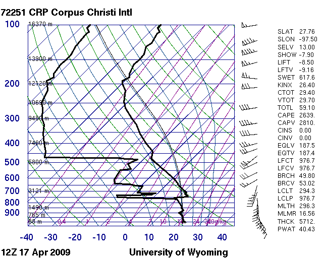
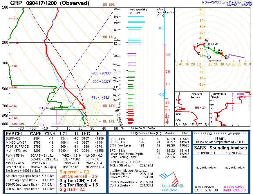
Amazing Sounding: Corpus Christi

Get a napkin ready to wipe the drool off of your face after you see these soundings:


You don't see stuff like this very often!

Wednesday, April 15, 2009

Researching The 2006 Marcellus, NY Tornado

Not much in the way of exciting weather is going on this week. Hopefully we'll see a more favorable environment for storms in the Northeast somewhere around the end of April.

For one of my classes, I have decided to do a case study of the F0 tornado that struck my hometown of Marcellus, NY back in 2006. I will post the paper here when it is done.

For those of you wondering why I haven't put up my research from earlier this year up, it is because I forgot to. I'll put a research tab on the left-hand link area and throw the powerpoint and other stuff in there.

It looks like I may be going to NCSU in the fall, so I will probably not have any more NY pictures to post after the move. However, I will keep updating this site and adding on to it, and I will probably also start another blog that is more general and caters to me having to move around a bit over the next several years. This blog has been going for about a year now (1 year anniversary is April 19th, yay us!), and I have learned a lot from doing it. I hope that people other than myself have found this site to be useful in one way or another.

Sunday, April 12, 2009

Brushfire Leads To 6-Alarm Blaze On Staten Island

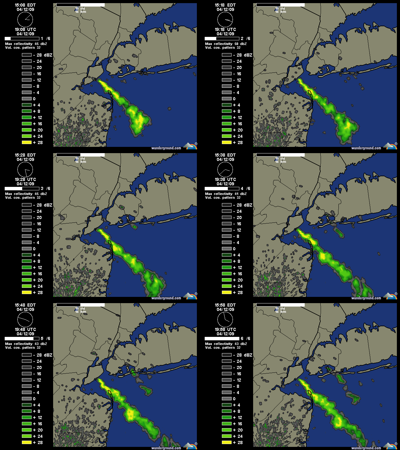
Around 1:00pm local time, a brush fire broke out on Staten Island. It has quickly grown into a 6-Alarm fire, and is threatening homes and infrastructure. One home is completely engulfed in fire, and other houses are at risk of becoming ablaze as strong winds push the smoke and ash southeastward.

Here is a radar from earlier today, with the smoke plume clearly visible to the southeast of Staten Island:


Links with early reports on the fire:
http://www.silive.com/news/index.ssf/2009/04/brush_fire_on_staten_island_ca.html
http://www.ny1.com/content/top_stories/97273/crews-battle-massive-brush-fire-on-staten-island/Default.aspx

More news on the brush fire as it develops. Fellow blogger Mark McIntyre is within three-minute walking distance from his house to the intense fires, and he will have some eyewitness information for us soon.

Saturday, April 11, 2009

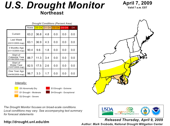
Dry Northeast Starting To See Drought Conditions Arise

Since the start of the year, NY and the Northeast has seen below-average precipitation amounts, and it's starting to show. Below average monthly precipitation totals have been recorded throughout most of NY since January, and the next week looks like it will only add to the deficit, as a series of high pressure systems keep rain out of the Northeast.


While drought conditions are still relatively minor, a couple more months of prolonged dry weather could see these conditions rapidly deteriorate, which does not bode well for farmers as planting season for many crops is just around the corner.

To keep up with the drought conditions in the Northeast, you can visit the following link:
http://www.drought.unl.edu/dm/DM_northeast.htm

Thursday, April 9, 2009

Lull In NY Weather, So Here's A Couple Weather Links!

Since it looks like the weather in NY will be pretty boring for awhile, here's a couple of weather links to keep you on the up-and-up on forecasting!

1. METAR data (defaulted to KALB for 60 hours) - Courtesy of UCAR
What it is: This site shows us the METAR weather code for virtually any station. This link is so special because it was really hard for me to find.
Why it's awesome: Take a good look at the URL. This link is for KALB, but you can enter any four-letter station ID you wish. Also note the "hoursStr=past+60+hours" section. The 60 can be made to any 12-hour interval you desire, for up to a month out into the past (~756 hours max)! This is a very nice feature, as you can look up what kind of weather a station has been having for the last month, which is useful to those who participate in forecasting contests like myself.

2. TwisterData.com - Courtesy of TornadoVideos.net
What it is: A high-res look at the nation from the GFS and NAM forecast models. This site is pretty expansive in its features, allowing you to look at dozens of different model outputs in an easy-to-navigate manner.
Why it's awesome: Easy to use, awesome features, and it's still in its infancy! Expect to see new features added to this site to make it even more user friendly in the near future, along with more model data (see the site for specific details). It also has a four-day archive of model outputs, so you can compare 16 different NAM/GFS runs if you want to! This site makes it really easy to look at severe weather components, which saves me a bunch of time since I don't have to look at several different sites to get my wind, moisture, and sounding data anymore.

Take them, cherish them, and get to know them! These two links provide me with a lot of information that I use on a regular basis, and I hope you will find them as useful as I do!

Sunday, April 5, 2009

Another Chance For Elevated Convection For Monday. Also, Snow...

As yet another low pressure system pushes into the Northeast, NY is faced with the possibility of thunderstorms associated with elevated convection. The thunderstorms are expected to pop up along an occluded front Monday morning, and push northeast from western NY to eastern NY throughout the mid-morning and afternoon hours.

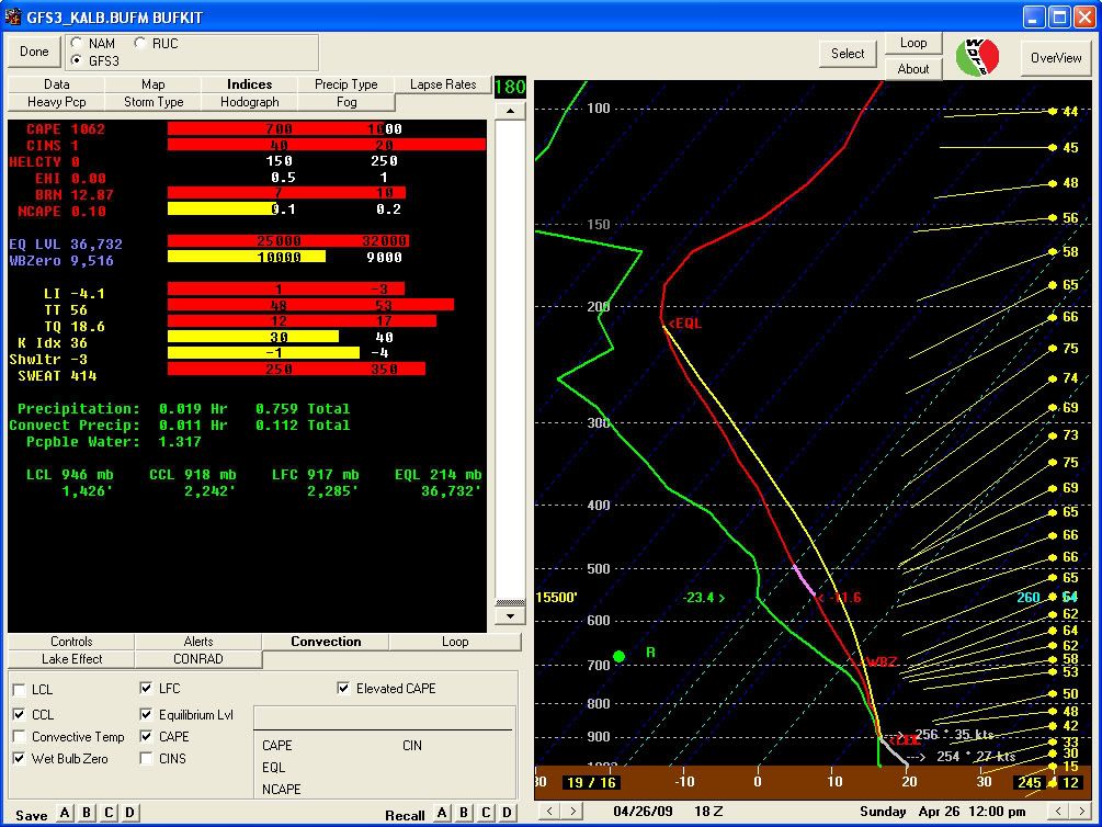
The GFS is being a lot more generous than the NAM with elevated CAPE in NY, with values of over 800 J/kg over Albany at around 2pm EDT. NAM is suggesting more moist mid- and upper-levels, with elevated CAPE values of less than 100 J/kg. P-Wat values of about one inch will help fuel the storms as they push through NY.

The main discrepancy between the models is the overall strength of the mid- and upper-level jets over NY. The GFS is forecasting stronger mid- and upper-level winds, which would advect steeper lapse rates into these levels and provide the larger elevated CAPE values. I tend to go with a mean value over Albany, since the GFS tends to overestimate CAPE values, and the NAM slightly underestimates it. Realistically, I would expect Albany to hit elevated CAPE values of 200-300 J/kg...enough to trigger some boomers!

This line of possible thunderstorms will also bring heavy rain, with a large portion of NY progged to receive over half an inch of precipitation. Lesser values are forecasted for areas not fully affected by this line of storms.

Following the passage of the occluded front, snow is expected throughout most of NY. Temps will reach below freezing at times in much of the western half of NY, which could see some snow accumulations. Areas affected by lake effect could see very generous snowfall totals for this time of the year, with 3-6"+ expected in the stronger lake-effect bands. In the eastern half of NY, temps will be a bit warmer, so valley areas could see some snow showers mixed with rain, but little to no accumulation. Elevations above 1200' in eastern NY can expect to see some snow accumulation from the trailing end of this storm.

Thursday, April 2, 2009

Thunderstorms in ALB tomorrow?

So after the nice complex of storms that affected the Southeast and Gulf Coast states today, us weather nerds up here at UAlbany are looking forward to the possibility of more thunderstorms tomorrow. The 990-hPa low that is currently over AR/TN will make its way northeastward towards us, eventually taking a track west of the Capital Region. Appended is the SPC's current Day 2 outlook, followed by total precipitation forecast ending 0000Z 4 April 2009.