Monday, March 30, 2009

Storm Creates One Last Day Of Havoc As It Moves Off The Coast

The most recent storm, which brought plenty of severe weather across the Southeast and Mid-Atlantic, still had a trick up its sleeve before moving off the coast yesterday. A very stacked and very strong low pressure center worked its way over PA and NY, which brought a great amount of energy into the region. This energy took the form of severe thunderstorms, which worked their way over the eastern half of PA, eventually coming into contact with NJ, southern NY and NYC/LI.

3/29/09:


Albany saw its first round of thunderstorm activity last night. Unfortunately, I was at work, and could not really watch it or take any video.

Welcome to Spring!

Sunday, March 29, 2009

Staten Island Got Hail!

Yes, Staten Island managed to get hail with the line of storms that passed through tonight. The size was 0.88", or nickel-sized, which qualifies the thunderstorms as severe! Here is the verification from the SPC:

0015 88 8 SW TOMPKINSVILLE RICHMOND (STATEN NY 4055 7418 NICKEL SIZED HAIL (OKX)

And here is the image of all of the storm reports from the SPC:


Here is an image of the hailstones that my little brother took during the storm:

Severe Weather Hits NYC and I'm NOT THERE!


Well, NYC is about to get its nice first batch of severe weather of the season, and I'm not at home. I'm working on my Synoptic II paper, but still monitoring the radar, and I must say, it looks nice. A very well-defined hook echo was visible tracking northeastward from Bergen County (NJ) into Rockland County (NY). More posts will come later when it has passed.

Saturday, March 28, 2009

Elevated Convection Potential In NY Tomorrow

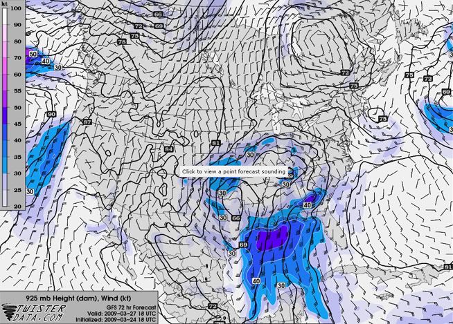
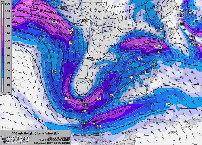
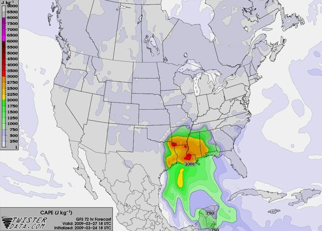
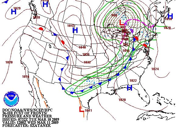
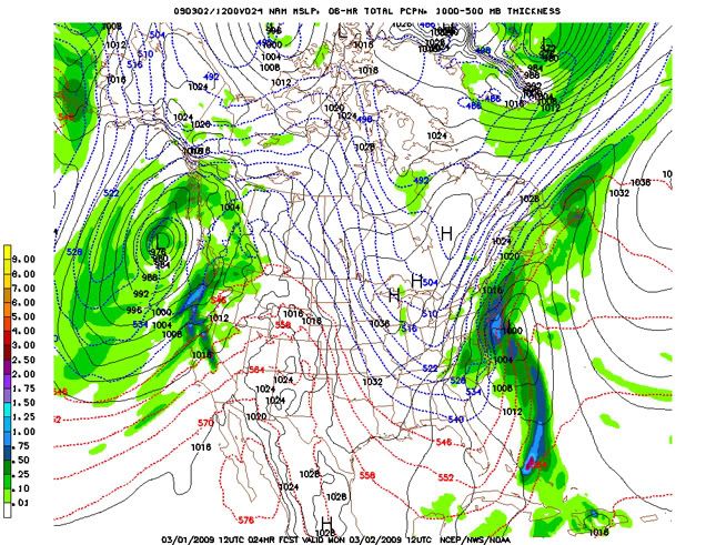
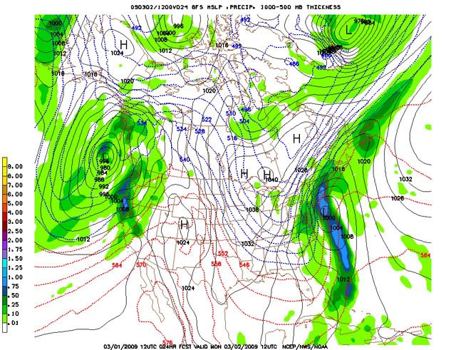
The storm that is currently wreaking havoc from the Great Plains eastward is going to push into the northeast over the next couple of days. Most of the upper-level forcing associated with this storm will be over western NY on Sunday, and will push eastward in the afternoon and overnight hours. Elevated CAPE values in the 500-800 J/kg range will also help lift air parcels and create some interesting weather over NY tomorrow.

There is a possibility of an elevated squall line development along the cold/occluded front tomorrow across NY and PA eastward. While NY may only get a taste of it, it just needs to get far enough north to let me snap some shots of it! The only downfall is that I work tomorrow evening, so the chance to watch it depends solely on when the front plans on passing through.

From the most recent AFD from the ALY NWS:

A SECONDARY CONCERN FOR SUNDAY...WHICH COULD HAVE A DIRECT IMPACT ON
QPF AMOUNTS...IS FOR ANY ELEVATED CONVECTION. THE LATEST 12 UTC
NAM12 SHOWS FORECASTED SHOWALTER VALUES LESS THAN ZERO ACROSS THE
ENTIRE CWA JUST BEFORE THE PASSAGE OF THE OCCLUDED BOUNDARY...WITH
VALUES AS LOW AS -3.5 MOVING FROM ACROSS THE SCHOHARIE VALLEY AND
CAPITAL DISTRICT. THE NAM12 IS ALSO VERY IMPRESSIVE WITH FORECASTED
850-500 HPA LAPSE RATES OF 6.5-6.9 DEGREES C/KM. ALONG WITH LOCALLY
HEAVIER RAINFALL AMOUNTS...LAPSE RATES OF THIS MAGNITUDE COULD ALLOW
FOR SOME SMALL SOFT HAIL /GRAUPEL/ AS WELL. THE THREAT FOR THUNDER
WOULD BE INCREASED AS WELL IF ANY BREAKS IN THE CLOUDS
OCCUR...ALTHOUGH BOTH THE NAM12/GFS IMPLY ACCORDING TO 850 HPA RH
THAT THIS WOULD REMAIN FURTHER SOUTH ACROSS CENTRAL PA. INCREASING
THE CONFIDENCE IN THIS IS THE LATEST 12 UTC LOCAL HIRESWRF...WHOSE
FORECASTED COMPOSITE REFLECTIVITY SHOWS A BKN CONVECTIVE LINE
DEVELOPING LATE SUN AFTN ACROSS NORTHEASTERN PA...AND ADVANCES IT
TOWARDS OUR CATSKILL/MID HUDSON VALLEY ZONES BY EVENING. SPC ALREADY
HAS OUR REGION OUTLINED IN GENERAL THUNDER...WITH A SLT RISK
REMAINING TO OUR SOUTH ACROSS SOUTH JERSEY AND THE DELMARVA.

Tuesday, March 24, 2009

Strong Severe Outbreak Potential For The Southeast March 27-28

Though the exact timing and overall strength of the storm is still debatable, the models are agreeing that a significant storm will dig down from the Northwest into the large scale upper-level trough that is currently over the central U.S. during the second half of the work week. The main discrepancy in timing the storm lies as to whether or not the storm will cut-off, or remain in the main flow. This storm has the potential to wreak havoc from eastern Texas eastward across the Southeast. On the other side of the storm, widespread winter weather is possible for areas as far south as northern Texas, in a swath that extends north and east into the Great Lakes as time progresses.

The general consensus among the models shows an impressive upper-level vort max digging into the Texas region Friday as it bottoms out in the large-scale trough. An upper-level jet in the base of the trough will provide southwesterly winds, which will draw the dry upper-level air off of the Mexican Plateau into the South and Southeast. This will create good upper-level lapse rates and decrease the upper-level stability.

The cold front currently draped over the Midwest and Southeast will stall in the South and Southeast Wednesday, which will continually draw Gulf moisture into the Southeast over the next few days. A couple of weak systems are expected to form off of this boundary and move off to the northeast before the big storm makes its way in. There will be enough instability south of this boundary to initiate some severe weather Wednesday through Friday, but nothing significant is forecasted for this time period.

The low-level moisture that will be in place over the Southeast will provide a good source of instability for the main storm when it enters the region, with surface dewpoints forecasted to be in the lower 60s at the time of arrival of the storm. A Bermuda High will also be in place over the next few days, which will enhance the southerly flow off of the Gulf of Mexico.

Along with the impressive vort max in the 500mb level, The strength of the lower- and upper-level jets seem to be the major players for this storm. The main concern is with the forecasted strength of these jets. The GFS has the most robust forecast for this storm, with strong upper-level winds bringing in dry air aloft, and a strong southerly jet in the lower-levels, which will draw the moist Gulf air north and provide significant low-level wind speed shear. Weaker winds for either jet can quickly turn this disaster scenario into a more moderate event.

All that being said, I am going to side closely with the GFS, as it has done fairly well with forecasting the first few big troughs of the season, with surprisingly good accuracy in the 4-6 day range. Both the GFS and NAM are forecasting a generous area of 2000+ J/kg CAPE, with some areas possibly exceeding 3000 J/kg CAPE (with a bulls-eye over Louisiana). P-Wat values are forecasted to be in the 1.5"-1.75" range when the storm arrives in the Southeast. Impressive low-level speed and directional wind shear will lead to plenty hail and a good amount of severe wind and tornadic activity in the Southeast. A nice cap will also be present around the 850mb level, before getting eroded by diurnal heating and vertical motion, which rounds out the setup for a classic "loaded gun" environment.


Sunday, March 22, 2009

Mon/Tues Outbreak Potential In The Great Plains

The dull weather continues in NY, so I thought I'd do a severe weather analysis for the upcoming storm:

The ingredients are beginning to mix a little better together as the Big Day approaches. Over the last few days, the models have put together a stronger westerly jet in the base of the upper-level trough, which will serve to bring in drier air off of the Rockies into the upper atmosphere. This will provide the Great Plains with about 500 J/kg more CAPE than was predicted a couple of days ago, putting the total forecasted CAPE in the 1000-1500 J/kg range for the more unstable areas. However, low-level moisture is still an issue, as forecasted surface dewpoints in the 50-60 range for most of the severe weather threat area decreases the great potential instability associated with this storm system.

Wind speed shear associated with a low-level southerly jet ahead of the system has improved as well, which not only increases the low-level instability, but also helps draw Gulf moisture further north. The great wind shear generated by this system will provide a favorable environment for supercell thunderstorms, with plenty of hail, strong winds and some tornadoes.

Storm formation will be hindered in the early part of Monday due to a nice cap in the mid-levels, with a lack of major instability near the surface. The big guns will likely show up in the late afternoon and early evening hours in the Great Plains as the cap breaks down, and push eastward in the overnight hours. The severe storms will likely continue working their way into the Midwest and Southeast Tuesday, causing a bit of mayhem in those regions as well, but they should not be as intense as Monday night's storms.

Some pretty forecast graphics for everyone to enjoy:


Friday, March 20, 2009

Upcoming Project... Making Databases

This Spring and Summer I plan on making several databases concerning severe weather in NY...from SPC storm reports to the actual warnings to pictures to maps and other data. I'm going to start with the most recent stuff and work my way back. I'll also post links to the blog for the dates where possible. This ought to be interesting...

Wednesday, March 18, 2009

Cold Front Brings Rain, Slight Cool-down

A cold front will bring rain and a few rumbles of thunder into NY today through tomorrow morning. A brief period of cooler weather will follow the front into Friday...temps will be about 3-5 degrees below normal, with highs in the lower 40s for Albany. It will quickly warm back up to normal Saturday, and these normal temps (highs in the upper 40s for Albany, with some lower 50s thrown in) will continue through mid-week next week as another ridge takes a seat over the eastern portions of the US.

Yay...another week of boring weather for NY... *sigh*

In my map discussion during class yesterday, I mentioned the possibility of severe weather in the Great Plains for Monday/Tuesday next week due to the trough that will be digging into the southwest US over the weekend. The SPC is on board with this prediction, and issued the outlook today as confidence increased from yesterday.


At this point and time, the situation doesn't look too crazy. Just your typical severe weather pattern here... no real plans to turn into a huge outbreak. The big thing hurting this storm will be the lack up good upper-level lapse rates, which takes a big chunk out of the possible CAPE...otherwise this storm would be a lot scarier. To get this CAPE, the trough will have to dig a bit deeper to tap into the dry upper-level air that the Mexican Plateau has to offer. P-Wat values (provided by the Gulf) are pretty good, and the low-level shear (in the surface-3km range) looks impressive, so it definitely looks like we'll see a few good storms in the Great Plains (and perhaps pushing into the Southeast) Monday and Tuesday.

There is a SLIGHT possibility of getting some severe weather action from this system in NY as it pushes north and east. The main concern will be the strength of the ridge over us as the storm tries to move into NY. If the ridge is too strong, the storm will slide north and just give us some rain. Still, we're talking seven days out at this point, so hopefully a more favorable severe weather forecast will come into play later this week!

Friday, March 13, 2009

Spring Is Here...Warm, Parched

It appears as though winter has thrown in the towel for this season in NY. Warmer temps that are slightly above normal for this time will be the main weather factor through the beginning of next week. Aside from a chance of rain mid-week next week, we'll generally have fair weather as a high pressure dominates the region.

So get the last of the snow out of your yard, get the car cleaned and ready for Spring, and take a nice walk outside, as the next five days or so will be a great time for all of these activities! We have the outdoors back!

Tuesday, March 10, 2009

Severe Weather Potential In Western NY In The Morning

I've been watching this storm form since Saturday, but I haven't had the foresight to post about it here until now. A storm brewing in the Midwest will push northeast and enter NY during the morning hours tomorrow, 3/11. Up until now, it looked like NY wouldn't get into the severe action, as the occluded front was forecasted to pass through. However, recent models and forecasts indicate a brief period in the warm sector of the storm, which might give that little extra push needed to put some wind reports in NY.

SPC doesn't have western NY in the slight region, but they've done this before with cases where we've had multiple wind reports:


HPC's surface forecast for this storm continues to improve NY's chances of getting severe storms:


That brief warm period may have what it takes to give us our first multiple-report day of the year!

Wednesday, March 4, 2009

Downtime... Presentation Coming Soon!

I'm getting my presentation for the 34th Annual Northeastern Storm Conference ready, so I won't be making any real updates this week.

NY: Warmer temps ahoy! We finally get to see a good warm-up period!

Keep an eye on the South on Sunday!

Sunday, March 1, 2009

Snow To Wreak Havoc In Southeastern NY And The East Coast

A powerful storm is already creating quite a mess in parts of the southeastern US today, and will make its way up the east coast tonight, bringing heavy snow to NYC and southeastern NY.

All of the models are in pretty strong agreement as to the path and timing of this storm as it progresses north and east. The UKMET is the only major deviation, with a more easterly track, which would spell lighter snow accumulations for NY. Most of the other models are calling for a big QPF of 1-1.2" over NYC, which will equate to 8-14" of snow by Monday afternoon. Long Island is likely to see even more, with an estimated 12-18" of snow, since it will be in the more intense area of precipitation. This will make it a real headache for people to get anywhere in NYC and Long Island.

Here are the NAM and GFS 24-hour forecasts for 6-hour QPF (to fall just before the morning commute on Monday):


This storm is going to inundate much of the east coast, including the major metropolitan areas of Washington, D.C., NYC and Boston. It's the storm that's been long in the making, and many people were sure/hoping it was going to come. I have a feeling a lot of people are going to stay home on Monday.

Here's a little awesomeness from Atlanta, GA:
KATL 011752Z 32015KT 1/4SM R09R/3500V4500FT +TSSN FG OVC004CB 01/00 A2972 RMK AO2 TSB37 SLP067 OCNL LTGIC OHD TS OHD-ALQDS MOV SW 4/001 P0013 60060 T00060000 10067 20006 51013

Heavy thundersnow, with an inch of snow falling in that hour!

The snowfall amounts quickly drop off in NY as you move north and west. Albany is on the outer fringe of the larger snowfall area, and is expected to receive 2-5" from this storm. Parts of western and central NY will see some lake effect snow on the order of 1-3" as the storm moves off the coast. Lake effect accumulations are light because the winds will be northerly, which gives the air less time to gather moisture from Lake Ontario and Lake Erie.

The rest of the work week looks to be pretty fair in NY, with a chance of mixed precipitation on Friday and Saturday.

UPDATE:
Following the trends of the newer model runs, I'm upgrading the Albany snowfall total to 4-6". Isn't nowcasting fun?