
2/11/09
My prediction for a tornado outbreak on the 10th was confirmed by additional reports that came in yesterday after storm damage was analyzed in the southern Great Plains:
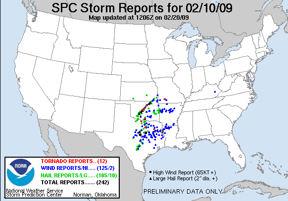
It just squeaked in as an outbreak, with the minimum of six tornado reports, but was an outbreak nonetheless. The wikipedia article on this event is a little contradictory, stating that there were seven tornadoes reported. Included is an EF4 wedge tornado, with unfortunately cut through the town of Lone Grove, Oklahoma, which has thus far killed at least 9 people, with about 50 others injured. A local news station, KOCO, has video footage of an EF2 tornado taken from their news helicopter. The severe potential is minimal through the rest of the week, which is good news for those involved in the cleanup from these storms.
As this storm moves off the coast, NYS is left with near-normal temps, with lows in the teens and highs in the low to mid 30s. Today will remain windy, with scattered rain and snow showers as temps fall throughout the day. Expect drier conditions to dominate our weather from tomorrow until around mid-week next week. The latest model runs indicate a mixed-precip nor'easter, which could greatly affect NYS weather around Wednesday. I will keep an eye on this system, and report on it later this week as I get a better look as to how this storm will track.
UPDATE:
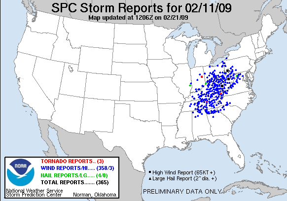
As reports and assessments continue to come into the NWS, the tornado count for February 10-11 is up to 11, with two more tornadoes occurring the next day.
Also updated to include the new wind report that popped up.

No comments:
Post a Comment